How Google Maps put the world on the right track
Posted in Apps and mobile devices
Finding directions to that job interview, event or hotel before the advent of Google Maps consisted of using an outdated map book (who remembers those?) and a lot of trial and error. These days most of us cannot imagine life without this revolutionary piece of technology guiding our travels. In fact, many of us get lost without an artificial voice telling us where to turn left.
No company has yet to come close to Google’s directional wizardry so it’s no wonder that there is a long history behind it.
Google Maps was the brainchild of two Danish brothers, Lars and Jens Rasmussen, from a company called Where 2 Technologies. It started out as a C++ program designed to be distributed through individual user downloads. Later the brothers pitched a product to Google that would be entirely hosted on the Web. As a result a lot of money was pushed into Australia (where the brothers were based when they created the program), making it one of the leaders in the world of online services.
Google acquired Where 2 Technologies in 2004 in order to transform the program into what we now know as Google Maps. Within that same time period, Google also acquired Keyhole (which had controversial dealings with the CIA at the time) to get hold of their Earth Viewer application. This geospatial data visualisation software later became Google Earth.
The launch of the Google Maps application was announced on Google’s Blog in February of 2005. Originally, only Microsoft Internet Explorer and Mozilla Firefox users could use the application but Safari and Opera support was added later. It was a beta application for six months before becoming a fixed part of the Google landscape.
The Google Maps API was released in 2005 to allow developers to integrate the application into their websites with no ads and free of charge. On July 20 of 2005, the company celebrated the 25th anniversary of the Apollo moon landing by launching the Google Moon application to accompany Google Maps and Earth. For those of you who don’t know, there’s also a Google Mars for you to explore!
The much-loved Street View was launched as part of Google Maps in May of 2007. The first cities to ever get this feature were San Francisco, Las Vegas, Denver, Miami and New York City. After the United States was covered, Street View became available for France and Italy. Then it was Australia and Japan. Even though one is inclined to think this, Street View is actually not yet available worldwide. But new locations are always being added. Interesting side note; the areas with the clearest, highest-quality imagery on Street View include South Africa, most of Europe, Southeast Asia, Canada and Latin America.
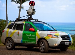
When Street View was first announced, it was seen as more of an experimental project. A company called Immersive Media was originally outsourced to capture images of the four of the first five cities to appear on Street View. Later on, the Google Street View cars were introduced making every piece of data they collect their own property. Back in the day several computers had to be put into the back of an SUV to support the cameras, lasers and a GPS device stuck onto the roof of the car. Did you know that Google’s self-driving cars have never gotten any tickets for traffic violations?
For the more difficult locations that can’t be reached via car Google uses the Street View Trekker. This is a wearable backpack with a camera mounted on top which is great for places that can only be captured by going on foot. Places the Trekker has explored include the Grand Canyon. If you’re the adventurous type with access to hard-to-reach places, you can apply to use a Trekker and map locations on behalf of Google (http://www.google.com/maps/about/partners/streetview/trekker/).
Other mapping gadgets that Google use include the Street View Snowmobile for colder climes, Street View Trolley to capture inside museums and other indoor locations, and the Street View Trike for narrow alleyways, theme parks and zoos. By the way, a trike is a three-wheel pedicab (like a tricycle) that needs a single person to pedal it along as if cycling.
To capture seamless images, there is a process the Street View team needs to go through. Google’s cameras have a 360 degree view. As it rotates, multiple images are captured all around the car as it is driving (very slowly). Capturing the best images depends on the weather as well as the population density of an area. Each image is matched to the correct geographical location by combining signals from sensors on the car that individually measure location, speed and direction. This reconstructs the exact route and helps to tilt and realign the images should it be needed.
The images now need to merged together to form a panoramic, flowing image. Images are overlapped slightly in order to close up any gaps and then they are stitched together to create a single image. Google has image algorithms that lessen the seams between images and make images transition more smoothly from one to the other.
Lasers on top of the Street View car bounce off objects surrounding it and tell Google engineers how far or close an object like a building really is. This process allows Google Maps to create 3D models (one of the newer features of the application).
Another interesting fact about Street View is the little yellow character you can transfer onto the map. The majority of places have the pegman (as the yellow man is called) but some locations are a bit different. Legoland in California’s character is made of Lego (of course), Hawaii’s pegman is a surfboarder and Half Moon Island (in Antarctica) has a Chinstrap Penguin. Some sports arenas will show the pegman with sportswear on and at NASA headquarters the pegman is an astronaut.
Some countries no longer have updated Google Maps images due to privacy concerns raised by these countries’ governments. Germany and India are two of these countries. Australia’s updates were also ceased in 2010 but they were started up again in 2011. If your country is still getting Street View updates, go here http://www.google.com/maps/about/behind-the-scenes/streetview/ to find whether Google’s Street View car is currently driving in your country. Who knows, maybe you can become mildly famous as one of the faces of Street View.
How frequently is Google Maps updated? Satellite imagery is updated every 2 weeks. This all depends on the location and availability of data. Also, the weather plays a big role in whether this update can be done (storms and clouds often disrupt updates in certain locations). It is difficult to pinpoint how frequently Street View is updated and Google Earth is usually updated every two months.
Google’s road maps are continuously updated but since so many changes occur daily (such as roadworks), there will still be inconsistencies and errors every now and then. Google relies heavily on user feedback to let them know of any changes. You can add locations, businesses, and roads yourself to make it easier for Google to pick it up, verify and add it.
You may have seen that Google Maps provides you information on traffic conditions but the early version of this was not as accurate as it is now. When Maps was introduced they based traffic conditions on historical data about traffic flow. Nowadays, traffic information is given in real-time showing people how long it will take to arrive at a destination (it also considers if you are driving a car, using public transport, biking or walking) and how heavy or light the traffic is.
However, many people have been outraged about how this real-time data is collected. Basically the data is being anonymously crowd-sourced from anyone with a cellphone travelling at any point in time. Yes, that includes you as well. There are ways to opt out of Google using your travel data but the company insists where you’re going to and coming from gets deleted as soon as you arrive at your destination. On the one hand, it has been helping people dodge traffic since 2007 but are people comfortable with this type of anonymous data collection?
Despite people complaining about the latest update Google Maps has undergone and the inaccuracies that are cropping up more frequently than before, there’s no denying its usefulness. This application accounts for one-third of all visitors to Google’s main site and 3% of all Web traffic comes from Google Maps. It is also consistently the most-popular app for smartphones. That type of world domination deserves some recognition. Besides, where would we be without Google Maps? Probably lost.